Annual River Monitoring
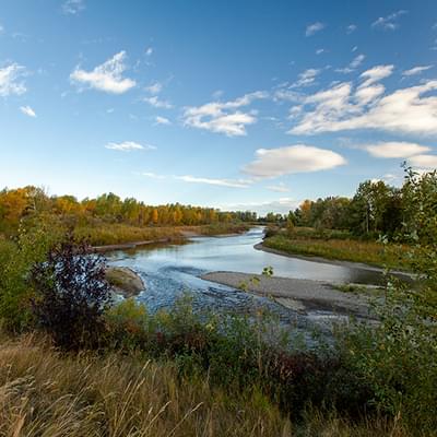
Living on the Highwood River means living with the rhythms of each season. To understand the yearly cycle of river monitoring, you need to understand the river. Find out more about the Town's annual river monitoring here.
Annual River Monitoring
Local river monitoring and observations are based on science and experience. We use data provided by experts - and based on this, the Town calls the shots to determine when action is required to protect our residents.
The town of High River monitors the river continuously. During peak hazard season, LED river monitoring signs are placed in high-traffic areas in Town to keep everyone informed.
Town staff monitor data specific to the Bow River Basin (Highwood River). Data includes real-time information about the snowpack and snowmelt and is compiled by monitoring stream flow and volume at key monitoring stations. Monitoring information is shared with the community weekly on the website and social media.
2026 River Monitoring Updates
River Monitoring Update - Tuesday, June 30, 2026
River Monitoring Update - Tuesday, June 30, 2026
As of 3:05 p.m. on Tuesday, June 30, the Highwood River is flowing at 171 cubic metres per second, with a depth of 2.841 metres. While precipitation is forecast over the coming days, no significant changes to river levels are expected at this time.
The town takes rainfall events and changing river conditions seriously. Protecting our community is our top priority, and we continuously review and strengthen our preparedness plans to ensure we're ready when conditions arise.
Over the past few days, residents may have noticed Town staff and equipment working in some low-lying areas. This is a normal part of our flood preparedness plan. As conditions evolve, crews actively monitor key locations and manage water where needed to help reduce impacts and keep infrastructure functioning as intended.
Rainfall events like this provide valuable opportunities to put our plans into action and evaluate how they perform. Following each event, staff review the response, identify opportunities for improvement, and update our procedures to ensure they remain effective, flexible, and responsive to our community's needs.
As river conditions continue to decrease, this will be the final River Monitoring Update for this rain event. The Town will continue to monitor river conditions, and regular updates will resume if conditions warrant.
Thank you for your patience, cooperation, and attention throughout this monitoring period.
We value your feedback and invite you to complete a short survey about our river monitoring and weather communications. Your input helps us improve how we communicate and respond during future events.
Learn more and complete the survey at highriver.ca/river-monitoring.
#HighRiver #RiverMonitoring
River Monitoring Update - Tuesday, June 30, 2026
River Monitoring Update - Tuesday, June 30, 2026
As of 9:05 a.m. on Tuesday, June 30, the Highwood River is flowing at 192 cubic metres per second, with a depth of 3.066 metres.
The Highwood River below the Little Bow Canal has now peaked, and both river flow and water levels are continuing to decline.
Although river conditions are improving, the ground remains saturated. Residents are encouraged to stay safe by using caution around rivers, ponds, and other water bodies.
Town staff continue to actively monitor weather & river conditions and remain in regular contact with provincial river forecasting partners.
Our next update will be shared on the Town's website and social media channels at approximately 4 p.m. today.
River Monitoring Update - Monday, June 29, 2026 | 4 p.m.
Environment and Climate Change Canada has issued a Yellow Rainfall warning for our area. It is expected to continue through to Monday night/early Tuesday morning with rainfall amounts of 50-100 mm. With this rain in the forecast, Rivers Alberta has issued a high stream flow advisory for the Highwood River.
Current modelling from Rivers Alberta indicates river flows could reach a peak of up to 340 cubic metres per second by tonight. While the forecast is higher than the peak we experienced earlier in June, it remains well below the historical 2013 flow rate of 1,820 cubic metres per second.
The flow rate at 12:05 p.m. today (June 29) was 162 cubic meters per second, with the river depth measured at 2.77 meters.
Residents are encouraged to:
- Ensure downspouts are directed away from your home's foundation.
- Check that sump pumps are working properly.
- Stay away from fast-moving rivers and streams, as water levels and currents can change quickly, especially during a High Stream Flow Advisory.
- Please be careful on low-lying roads and pathways where water may pool, pay attention to barricades and follow instructions you may see on signage. This is to ensure the safety of everyone in our community.
Town staff continue to actively monitor weather & river conditions and remain in regular contact with provincial river forecasting partners.
Conditions will continue to be monitored and any significant changes will be communicated through the Town's website and social media channels. Our next river monitoring update will be provided on our website and social media at approximately 10 a.m. Tuesday, June 30.
River Monitoring Update - Monday, June 29, 2026 | 10 a.m.
River Monitoring Update - Monday, June 29, 2026 | 10 a.m.
Environment and Climate Change Canada has issued a Yellow Rainfall warning for our area. It is expected to continue through to Monday night with rainfall amounts of 50-100 mm. With this rain in the forecast, Rivers Alberta has issued a high stream flow advisory for the Highwood River.
Current modelling from Rivers Alberta indicates river flows could reach a peak of up to 340 cubic metres per second. The peak is now expected tonight. While the forecast is higher than the peak we experienced earlier in June, it remains well below the historical 2013 flow rate of 1,820 cubic metres per second.
The flow rate at 9:05 a.m. today (June 29) was 123 cubic meters per second, with the river depth measured at 2.4 meters.
Residents are encouraged to:
- Ensure downspouts are directed away from your home's foundation.
- Check that sump pumps are working properly.
- Stay away from fast-moving rivers and streams, as water levels and currents can change quickly, especially during a High Stream Flow Advisory.
- Be careful on low-lying roads and pathways where water may pool.
Town staff continue to actively monitor weather & river conditions and remain in regular contact with provincial river forecasting partners.
Conditions will continue to be monitored and any significant changes will be communicated through the Town's website and social media channels. Our next river monitoring update will be provided on our website and social media at approximately 4 p.m. Monday, June 29.
River Monitoring Update - Sunday, June 28, 2026 | 4 p.m.
Environment and Climate Change Canada has issued a Yellow Rainfall warning for our area. It is expected to continue through to Monday night with rainfall amounts of 50-100 mm. With this rain in the forecast, Rivers Alberta has issued a high stream flow advisory for the Highwood River.
Current modelling from Rivers Alberta indicates river flows could reach a peak of up to 340 cubic metres per second on Tuesday, June 30. While the forecast is higher than the peak we experienced earlier in June (186cms), it remains well below the historical 2013 flow rate of 1,820 cubic metres per second.
The flow rate at 2:05 p.m. on Sunday, June 28 was 29.20 cubic meters per second, with the river depth measured at 1.47 meters.
Residents are encouraged to:
- Ensure downspouts are directed away from your home's foundation.
- Check that sump pumps are working properly.
- Stay away from fast-moving rivers and streams, as water levels and currents can change quickly, especially during a High Stream Flow Advisory.
Town staff continue to actively monitor weather & river conditions and remain in regular contact with provincial river forecasting partners.
Conditions will continue to be monitored and any significant changes will be communicated through the Town's website and social media channels. Our next river monitoring update will be provided on our website and social media at approximately 10 a.m. Monday, June 29.
River Monitoring Update - Sunday, June 28, 2026 | 10 a.m.
Environment and Climate Change Canada has issued a Yellow Rainfall warning for our area. It is expected to continue through to Monday night with rainfall amounts of 50-100 mm. With this rain in the forecast, Rivers Alberta has issued a high stream flow advisory for the Highwood River.
At this time, Rivers Alberta is forecasting peak flow that could be slightly higher than what we saw earlier in June, which was 186 cubic meters per second. The forecasted peak flow rate, with the rain, could be as high as 200 cubic metres per second and is expected to occur on Tuesday, June 30. The highest historical flow rate during 2013 was 1,820 cubic metres per second.
The flow rate at 8:05 a.m. on Sunday, June 28 was 25.40 cubic meters per second, with the river depth measured at 1.42 meters.
Residents are encouraged to:
- Ensure downspouts are directed away from your home's foundation.
- Check that sump pumps are working properly.
- Stay away from fast-moving rivers and streams, as water levels and currents can change quickly, especially during a High Stream Flow Advisory.
Town staff continue to closely monitor weather & river conditions and remain in regular contact with provincial river forecasting partners.
Conditions will continue to be monitored and any significant changes will be communicated through the Town's website and social media channels. Our next river monitoring update will be provided on our website and social media at approximately 4 p.m. today, June 28.
River Monitoring Update - Saturday, June 27, 2026
Environment and Climate Change Canada has issued a Yellow Rainfall warning for our area. It is expected to continue through to Monday night with rainfall amounts of 50-100 mm. With this rain in the forecast, Rivers Alberta has issued a high stream flow advisory for the Highwood River.
At this time, Rivers Alberta is forecasting peak flow that could be slightly higher than what we saw earlier in June, which was 186 cubic meters per second. The forecasted peak flow rate, with the rain, could be as high as 200 cubic metres per second and is expected to occur on Tuesday, June 30. The highest historic flow rate during 2013 was 1,820 cubic metres per second.
The flow rate at 4:05 p.m. on Saturday, June 27 was 21 cubic meters per second, with the river depth measured at 1.38 meters.
We recommend if you have downspouts to have them lowered so that water can be directed away from your house and to check your sump pumps to ensure they are operational.
Town staff are monitoring conditions and remain in regular contact with provincial river forecasting partners.
Our next river monitoring update will be provided on our website and social media at approximately 10 a.m. tomorrow, June 28.
River Monitoring Update – Wednesday, June 17, 2026
River Monitoring Update – Wednesday, June 17, 2026
The Highwood River is currently flowing at 28.50 cubic metres per second with a depth of 1.572 metres. While some precipitation is forecast over the coming days, no significant changes in river levels are expected at this time.
To put that into perspective, the recent rainfall event saw river flows peak at 186 cubic metres per second. Current conditions remain well below that level.
Town staff continue to monitor river conditions, weather forecasts and will provide updates if conditions change.
River Monitoring Update – Wednesday, June 10, 2026
River Monitoring Update – Wednesday, June 10, 2026
The Highwood River (below Little Bow Canal) is currently flowing at 37 cubic metres per second, with a depth of 1.691 meters. For comparison, during the most recent rainfall event, the river reached a peak flow of 186 cubic metres per second.
Precipitation is forecast for the coming week; no significant changes in river levels are expected currently.
Precipitation is forecast for the coming week; no significant changes in river levels are expected currently. Town staff continue to monitor conditions closely.
River Monitoring Update - Wednesday, June 2
The Highwood River reached its peak flow last night at approximately 186 cubic metres per second at 8 PM. Since that time, we’ve observed a gradual and steady reduction in river levels. As of 10:05 a.m. on Wednesday, June 3, the Highwood River is flowing at 166 cubic metres per second, with a river depth of 2.916 metres.
We recognize that this time of year can be difficult for many residents. Rising river levels and periods of heavy rain can bring back memories and emotions associated with the 2013 flood. Those feelings are understandable, and we want residents to know that we take those concerns seriously.
Since 2013, High River has learned a great deal and invested significantly in flood preparation and mitigation. Today, the community is protected by an extensive flood mitigation system, including engineered berms and infrastructure design to protect the town from river flows far beyond what we have experienced this past week.
Thank you to our residents. Your cooperation, attentiveness and engagement have helped us navigate this period effectively. The strength of High River has always been found in its people. Once again, our community has demonstrated a willingness to stay informed and prepared.
As river levels continue to recede, Town staff continue to stay vigilant and monitor conditions. Together, we remain prepared, resilient, and ready for any challenge this hazard season may bring. The Town will now return to its regular Wednesday river monitoring updates.
If you have any feedback or thoughts to share about our communications about river monitoring and weather events, we invite you to complete a short survey on our website. Your feedback helps us refine our communication and response processes. Learn more: highriver.ca/river-monitoring.
River Monitoring Update – Tuesday, June 2, 2026 | 4:05 p.m.
River Monitoring Update – Tuesday, June 2, 2026 | 4:05 p.m.
As of 4:05 p.m. on Tuesday, June 2, the river flow rate is 170 cubic metres per second, with a river depth of 2.949 metres. For comparison, the highest historic flow rate in 2013 was 1820 cubic metres per second.
Residents may notice faster-moving water, higher water levels, additional debris in the river, and some localized pooling of water in low-lying areas throughout the community. This pooling is expected following significant rainfall and will gradually recede as stormwater systems continue to manage the excess water.
The Beachwood area will remain closed due to water-covered trails and soft ground conditions. For your safety, please avoid this area.
As conditions remain wet, residents are encouraged to keep safety top of mind, use caution around rivers, ponds, and other water bodies, and practice safe driving habits by slowing down, allowing extra stopping distance, and watching for standing water on roadways.
Our next update will be provided on our website and social media channels at approximately 10 a.m. on Wednesday, June 3. #HighRiver #RiverMonitoring
River Monitoring Update – Tuesday, June 2, 2026 | 10 a.m.
River Monitoring Update – Tuesday, June 2, 2026 | 10 a.m.
As of 10 a.m. on Tuesday, June 2, the Highwood River is flowing at 169 cubic metres per second, with a river depth of 2.86 metres. For comparison, the highest historic flow rate for the Highwood River was in 2013 at 1820 cubic metres per second.
Recent rainfall has led to higher-than-normal river flows, which is a natural response to significant precipitation. Residents may notice higher water levels, faster-moving water, and increased debris in the river; however, these conditions do not currently pose a flood risk to High River. Water levels remain well within established safety thresholds, and the Town's flood protection systems are performing as intended. Elevated river flows are expected to continue, with the river anticipated to peak within the next 24 hours. No impacts to homes, businesses, or community infrastructure are anticipated at this time.
Town staff are monitoring conditions around the clock and remain in regular contact with provincial river forecasting partners. High River has experienced similar weather events in the past and has established plans, systems, and trained staff ready to respond if conditions change.
As rainfall continues, residents are encouraged to check that their sump pumps are operating properly, as saturated ground conditions can increase groundwater entering drainage systems.
For public safety, the Beachwood area remains closed until further notice.
The Town will continue to provide updates as conditions evolve. The next river monitoring update is expected at approximately 4 p.m. today. Thank you for staying informed and helping keep our community safe.
River Monitoring Update – Monday, June 1, 2026 | 4 p.m.
River Monitoring Update – Monday, June 1, 2026 | 4 p.m.
As of 4 p.m. on Monday, June 1, the river flow rate is 87.30 cubic metres per second, with a river depth of 2.15 metres.
For comparison, the highest river flow recorded during 2013 was 1,820 cubic metres per second.
We are aware of wind-related damage throughout the community, including downed branches and debris. Town crews are actively assessing affected areas and clearing hazards as conditions permit and when it is safe to do so. Residents who notice downed branches, significant debris, or other safety concerns are encouraged to report them through our online Report a Concern system at highriver.ca/report-a-concern.
The Beachwood area remains closed to the public until further notice.
Our next update will be provided on our website and social media channels at approximately 10 a.m. on Tuesday, June 2.
River Monitoring Update – Monday, June 1, 2026 | 10 a.m.
River Monitoring Update – Monday, June 1, 2026 | 10 a.m.
#HighRiver continues to closely monitor river flow rates, water levels, and weather forecasts throughout the week. As of 10 a.m. on Monday, June 1, the river flow rate is 76.90 cubic metres per second, with a river depth of 2.053 metres.
We are aware of wind-related damage resulting in downed branches and debris throughout the community. Town crews are actively assessing and clearing affected areas as conditions allow and when it is safe to do so. Residents who notice downed branches, significant debris, or other safety concerns are encouraged to report them through our online Report a Concern system. Visit highriver.ca/report-a-concern for more information.
Due to water covering portions of the trail network, the Beachwood area remains closed to the public until further notice. These closures are in place to help ensure the safety of all trail users.
Our next river monitoring update will be provided on our website and social media channels at approximately 4 p.m. today, June 1.
River Monitoring Update - Sunday, May 31, 2026 | 7 p.m.
As we shared earlier in the day, Rivers Alberta has issued a high stream flow advisory for the Highwood River. At this time, the forecasted peak flow rate, with the rain, could be as high as 250 cubic metres per second. The highest recorded flow rate during 2013 was 1,820 cubic metres per second. The flow rate at 6:30 p.m. on Sunday, May 31, 2026 is 64.4 cubic metres per second, with the river depth measured at 1.92 metres. Due to water covering portions of the trail network, the Beachwood area remains closed to the public until further notice. While some areas may appear accessible, conditions can change quickly and submerged trails present safety concerns. Residents are asked to continue avoiding these areas while water levels remain elevated. The closures are in place to help ensure the safety of all users. The photos included in this update are from the Beachwood area earlier today. We will provide another update on social media and our website at 10 a.m. tomorrow, June 1.
High Stream Flow Advisory - Sunday, May 31, 2026 | 1 p.m.
The Town has been continuing to proactively monitor river flow rates, water levels and weather forecasts. Rivers Alberta has issued a high stream flow advisory for the Highwood River. At this time, the forecasted peak flow rate, with the rain, could be as high as 250 cubic metres per second. The highest recorded flow rate during 2013 was 1,820 cubic metres per second.
The flow rate at 11:30 a.m. on Sunday, May 31, 2026 is 61.7 cubic metres per second, with the river depth measured at 1.9 metres.
Due to water covering portions of the trail network, Beachwood and Mercer Lands remain closed to the public until further notice. While some areas may appear accessible, conditions can change quickly and submerged trails present safety concerns. Residents are asked to continue avoiding these areas while water levels remain elevated. The closures are in place to help ensure the safety of all users.
We will provide another update on social media and our website at 7 p.m. this evening (May 31).
River Monitoring Update - May 29, 2026
The Town of High River continues to actively monitor the river flow rates, water levels, and forecasted weather conditions throughout the weekend. While river levels and flow rates have increased in recent days, and additional increases are anticipated, the situation continues to be closely monitored and assessed on an ongoing basis.
Due to overland water in the area, Beachwood and the Mercer Lands are closed to the public until further notice. All residents are asked to avoid these areas.
As of 3 p.m. on Friday, May 29, 2026, the flow rate of the Highwood River below the Little Bow Canal is 65.30 cubic metres per second, with the current river depth measured at 1.934 metres. For context, the highest recorded flow rate during 2013 was 1,820 cubic metres per second.
Currently, monitoring and preparedness efforts remain proactive. Updates will be provided should any significant changes occur over the weekend.
River Monitoring Update – Wednesday, May 27, 2026
River Monitoring Update – Wednesday, May 27, 2026
The current snowpack level is on the low end of the seasonal average for this time of year and is currently at 159.80 mm of snow water equivalent.
The current flow rate of the Highwood River, below Little Bow Canal, is within normal rates at 39.90 cubic metres per second. Typical flows for this time of year range from 25 to 65 cubic metres per second.
Precipitation is forecast for the coming week; no significant changes in river levels are expected at this time.
Town staff will continue to closely monitor snowpack conditions and river levels throughout the hazard season.
River Monitoring Update – Thursday, May 21, 2026
River Monitoring Update – Thursday, May 21, 2026
The current snowpack level is on the low end of the seasonal average for this time of year and is currently at 278.80 mm of snow water equivalent.
The current flow rate of the Highwood River, below Little Bow Canal, is within the normal range at 24 cubic metres per second. Typical flows for this time of year range from 12 to 30 cubic metres per second. For reference, the highest level recorded in 2013 was 1820 cubic metres per second.
Light precipitation is forecast for the coming week; no significant changes in river levels are expected at this time.
Town staff will continue to closely monitor snowpack conditions and river levels throughout the hazard season.
River Monitoring Update – Wednesday, May 13, 2026
River Monitoring Update – Wednesday, May 13, 2026
The current snowpack level is on the low end of the seasonal average for this time of year and is currently at 319.6 mm of snow water equivalent.
The current flow rate of the Highwood River, below Little Bow Canal, is slightly above normal at 39 cubic metres per second. Typical flows for this time of year range from 12 to 30 cubic metres per second. For reference, the highest level recorded in 2013 was 1820 cubic metres per second.
Light precipitation and windy conditions are forecast for the coming week; no significant changes in river levels are expected at this time.
Town staff will continue to closely monitor snowpack conditions and river levels throughout the hazard season.
River Monitoring Update – Wednesday, May 6, 2026
River Monitoring Update – Wednesday, May 6, 2026
The current snowpack is within normal levels for this time of year and is currently at 469.20 mm of snow water equivalent.
The current flow rate of the Highwood River, below Little Bow Canal, is slightly above the normal rate at 26 cubic metres per second. Typical flows for this time of year range from 6 to 19 cubic metres per second.
Light precipitation is forecast over the coming week; no significant changes in river levels are expected at this time.
Town staff will continue to closely monitor snowpack conditions and river levels throughout the hazard season.
River Monitoring Information
Local River Monitoring Process
"We use data provided by experts but we know the river, and the Town calls the shots to determine when action is required to protect our residents." -Craig Snodgrass, Mayor of High River
Local monitoring and observations are based on historical events, science and experience
- Spring thaw, Spring rains and snowmelt are predictable cycles of nature.
- History demonstrates that when these events combine, the effect on the Town is not predicable.
- The Town conducts an annual Hazard Risk Vulnerability Assessment to determine conditions each Spring.
- In 2022, the Town will reach a milestone with the completion of Flood Mitigation infrastructure to protect our community, making High River one of the most flood protected communities in Canada.
- River monitoring, weather patterns and scientific data from the Province provides the intelligence required for timely and informed decision making.
- High River is recognized as a World class leader in flood planning and response.
- Town staff monitor and interpret data provided to us in real time by the province. Trigger points are established indicating when control measures must be activated to protect our community.
- The Town uses this information to ensure the safety of the community and its residents.
For more information, view the Living on the the Highwood River document.
Understanding River Monitoring Stages and LED Signs
Many factors, both natural and human-induced, cause rivers to continuously change. The definitions used on High River’s River Monitoring signs are standard terminology used by hydrologists who study and measure stream flow.
- Each year, the town places LED signs in high-traffic areas to inform residents of the hazards during peak hazard season.
- These signs intend to raise awareness of the risk potential.
The Town will inform residents if action is required based on the risk. Refer to Town information on the website and social media and listen for alerts.
The Town uses the provincial standard to monitor the river:
- Normal
- High Stream Flow Advisory
- Flood Watch
- Flood Warning
Action is not required until the Flood Watch stage, but it is always good to be prepared for an emergency.
To help understand the reported flow rates, please note that the river flow during the 2013 flood reached 1820 cubic meters / second.
Normal Flow Stage
Flow is measured by noting the amount of water passing by monitoring stations. This data is available in real-time for the critical stations monitored by Town staff on rivers.alberta.ca.
High Stream Flow Advisory Stage
Stream levels are rising rapidly, and no major flooding is expected. Minor flooding in low-lying areas is possible. Anyone close to the streams affected is advised to be cautious of the rising levels.
It is always important to be prepared if the stream flow advisory becomes a Flood Watch. Water volume and flow are ever-changing, and the advisory may be cancelled when flows return to normal. If volume and flow return to normal, this stage will be followed with the normal stage, or the advisory will be lifted.
Flood Watch Stage
Stream levels are rising and will approach or may overflow the riverbanks. Flooding of areas adjacent to these streams may occur. Anyone situated close to the river is advised to take appropriate precautionary measures.
Flood Warning Stage
Rising stream levels will result in flooding areas adjacent to the affected streams. Anyone near the river should take appropriate measures to avoid flood damage and injury.
Pay attention to Town information on the website and social media and listen for advice on actions required to protect yourself, your family, your pets and your home.
River Monitoring Updates
2025 River Monitoring Updates
River Monitoring Update - Friday, June 13, 2025
The current flow rate of the Highwood River below Little Bow Canal is below normal, at 8.52 cubic metres per second. Normal flows range from 25 to 65 cubic meters per second. Small amounts of precipitation are forecasted for next week; we are not expecting any significant changes in the river as a result.
Town staff will continue to closely monitor the snow and river for the remainder of the hazard season.
River Monitoring Update - Friday, June 6, 2025
The current flow rate of the Highwood River below Little Bow Canal is below normal at 6.59 cubic metres per second. Normal flows range from 25 to 65 cubic meters per second. Precipitation is forecasted for next week; however, we do not expect any significant changes in the river as a result. Town staff will continue to closely monitor the snow and river for the remainder of the hazard season.
River Monitoring Update - Friday, May 30
Snowpack is currently at 38 mm of snow water equivalent. The Highwood River below the canal is flowing below normal levels, and a water shortage advisory remains in effect along the river. A small amount of precipitation is forecasted for next week, with temperatures rising to mid-20s. Town staff will continue closely monitoring the snow and river for the remainder of the hazard season!
River Monitoring Update - May 23, 2025
Snowpack is currently at 198 mm of snow water equivalent, compared to 385 mm at this time last year. The Highwood River below the canal is flowing below normal levels, and a water shortage advisory remains in effect along the river. A small amount of precipitation is forecasted for next week, with temperatures rising to mid to high 20s. Town staff will continue closely monitoring the snow and river for the remainder of the hazard season!
River Monitoring Update - Friday, May 16, 2025
The snowpack is below average for this time of year and is currently at 236 mm of snow water equivalent. At this time last year, we were right around 375 mm of snow water equivalent. Currently, the Highwood River below the canal is still below average, and a water shortage advisory is in place on the Highwood River. The forecasts indicate some precipitation is expected over the long weekend and into next week. Town staff will continuously monitor the snow and the river situation closely for the remainder of the hazard season.
Highwood River Key Monitoring Stations
Alberta Environment and Parks has many river monitoring stations on their Rivers Alberta website. The Town focuses on those set up for the Highwood River Basin.
The stations monitored by the Town of High River are chosen because they provide the most relevant and timely data regarding the volume and flow as the river approaches the Town.
Data available includes daily real time information about:
- Snowpack and snowmelt information predicted by teams of experts who set stations up in the mountains at the river’s source
- Stream flow and volume as it passes by these stations
Staff also monitor temperatures and precipitation to anticipate potential impacts on the stream volume and flow. This monitoring data is available publicly and is shared with residents. High River staff monitor the river until the end of June.
Key Monitoring Stations: Highwood River
- Stimpson Creek near Pekisko
- Highwood River at Diebel’s Ranch
- Trap Creek near Longview
- Pekisko Creek new Longview
- Highwood Diversion Canal near the Headgates
- High River Below Little Bow Canal
Monitoring Data (examples)
If there are High Stream Flow Advisories, the area on the Rivers Alberta Map will be shown in yellow. Select the yellow bar and see a forecast link with additional information.
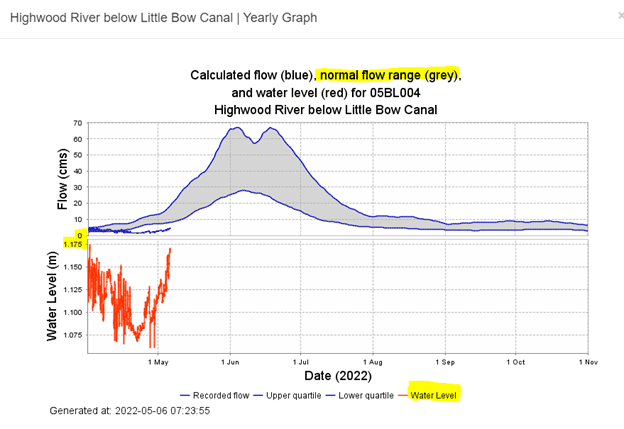
- Normal Range is shown in the grey bar
- Blue shows the highest recorded flow on these dates
- Red shows the current levels
- On May 6, 2022, at 8:18 AM, levels are shown below the normal flow (grey bar)
We're here to help, contact us!
Fire Services

Fire Hall 1010 5th St SE High River, Alberta

Monday to Friday 8:00 am - 4:00 pm

fire@highriver.ca

Fire Department: 403-652-3774
fireinspections@highriver.ca
Municipal Enforcement
Fire Hall 1010 5th St SE High River, Alberta
24/7 Bylaw Complaint Line: 403-603-3643
General Inquiries and Administration: 403-603-3644
hrps@highriver.ca
Report a Concern