Northeast Area Structure Plan
This plan will guide future land use, transportation, and infrastructure decisions for the northeast portion of Town.
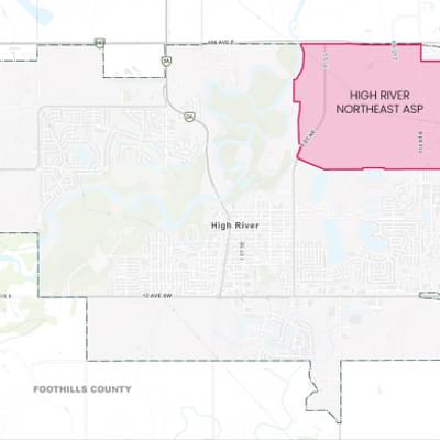
Project Background
The ASP area includes lands annexed from Foothills County in 2012 and 2021, situated west and east of 112 Street E, near the Highway 2A and Highway 2 interchange.
With increasing development interest, the Town sees this as an opportunity to plan for resilient growth over time.
This area offers the potential for walkable, mixed-use neighbourhoods, with development capitalizing on proximity to the highway, employment opportunities, and coordinated infrastructure solutions.
View the Project Background Report for more information.
Who's Listening
The Northeast ASP is being led by the Town, with support from our selected planning consultants, V3 Companies of Canada and Table Talk Communications & Engagement.
What is an ASP?
An Area Structure Plan (ASP) is a statutory plan used by municipalities in Alberta to guide the future subdivision, development and servicing of a specific area. A statutory plan must meet specific requirements in the Municipal Government Act (MGA). Area Structure Plans set the land use and policy framework that guides future planning initiatives for years or decades ahead (often 15-20+ years).
ASPs do not approve specific developments. After Town Council adopts the ASP, more detailed planning occurs through the creation of Neighbourhood Outline Plans (NOPs), land use bylaw amendments, subdivision applications, and development applications.
An ASP includes:
- A land use concept: This outlines where land uses will go within the plan area, including residential, commercial, parks, industrial areas, etc.
- Transportation network: Plans for roads, pathways, sidewalks, and other transportation infrastructure
- Servicing plans: Details on water, wastewater, and stormwater management
- Policies: Guidelines to direct future zoning and subdivision decisions
- Phasing of development: the development sequence proposed for the area, divided into phases
Planning Hierarchy

We're here to help, contact us!

309B Macleod Trail S.W., High River, Alberta

Monday to Friday 8:30am - 4:30pm (Closed on statutory holidays)

planning@highriver.ca

403-652-2110
Northeast Area Structure Plan Round 1 Engagement Round 2 Engagement