Joint Planning Area 4 Context Study
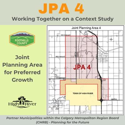
Town of High River and Foothills County working together along with landowners and interested parties on a Context Study for Joint Planning Area 4, as required by Calgary Municipal Regional Board's Growth Plan.

We will be adding some updates to this page in the New Year. Please check back. Thank you.
Working together on a Context Study for an area that includes lands in the Town and the County.
In partnership with Foothills County, the Town of High River has produced a "What We Heard Report" highlighting the results of the Planning Area 4 Context Study Phase 1 Engagement. View a copy of the report below:
What We Heard: Planning Area 4 Context Study Phase 1 Engagement (link)
The Calgary Metropolitan Region Board (CMRB) was established by the Government of Alberta in 2018 and includes eight member municipalities.
Under provincial legislation, members of the CMRB were required to work together to prepare a Growth Plan and a Servicing Plan to ensure a strategy would be in place to prepare for growth in the region. The development of the growth plan included three phases of engagement where landowners and stakeholders across the region were asked to provide input. The completed regional Growth Plan went into effect August 15, 2022.The Growth Plan will set the stage for the next 25-30 years, and plans for an anticipated population increase of one million people within the Calgary Metropolitan Regional area. All development in the region must now comply with the Growth Plan.
The Town of High River and Foothills County are working together on a Context Study for a Joint Planning Area made up of lands in both the County and the Town.
- View the Foothills County JPA 4 web page (opens a graphic)
This Joint Planning Area was identified in the regional Growth Plan and is known as JPA 4. A Context Study is a type of background report that looks at land use and servicing in an area that is of interest to both municipalities and where there may be opportunities for collaboration. Collaboration is important to the success of a strategic approach to anticipated future growth. It is also important to ensure property owners within the Joint Planning Area are aware of the plans and empowered with information to prepare for the future.
JPA 4 Context Study is required to be completed by August 2025
Commitment to Inform and Engage with Landowners, Interested Parties and the Public to Develop the Context Study
An Engagement Plan for this area was approved on December 7, 2023 by the Foothills / High River Intermunicipal Committee. Beginning in early 2024, Foothills County and the Town of High River will work together to inform and engage with landowners, interested parties and the public to identify key issues in the area and to develop objectives for the Context Study.
Things to watch for: Scroll down to the menus below for details.
Spring 2024: Letter to landowners and potentially interested parties including a survey.
Fall 2024: Public Open House: Once a date is chosen for the Open House it will be promoted and we look forward to seeing you there.
Contact Us:
You are invited to contact Foothills County or the Town of High River Planning & Development staff with your questions. We are committed to engaging with landowners, residents, businesses and other key interested parties when making decisions that have the potential to impact them.
Foothills County contact information:
- Email Julie Mclean, Deputy Director of Planning
- Telephone: 403-603-6239
Town of High River contact information:
- Email Sarah Peck, Planner II
- Telephone: 403-652-2110
Please read through the information below for more information, details, and useful links.
JPA 4 Detailed Information and Links to the CMRB for Background and Context
Joint Planning Area 4 (JPA 4) - Where is it?
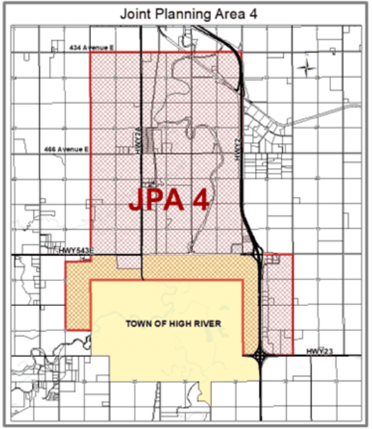
The Town of High River and Foothills County are working together on a Context Study for a Joint Planning Area made up of lands in both the County and the Town. This Joint Planning Area is known as JPA 4.
JPA 4 Area description
- The JPA 4 area extends along Highway 2A from 434 Avenue on the north to approximately one-half mile inside the Town of High River boundary.
- It also includes the Foothills Crossing Area Structure Plan lands along the east side of Highway 2 between 498th Avenue and Highway 23.
- JPA 4 encompasses approximately 5018 ha (12,400 acres) of land.
- 4350 ha (10,748 acres) are within the County and 668 ha (1652 acres) are within the Town.
The Context Study to be prepared by August 2025 will inform the future planning of this area.

JPA 4 Context Study Project - What is it?
The CMRB Growth Plan requires that the municipalities that are party to a JPA produce a Context Study by August 2025.
- It is anticipated that the focus of the Context Study will be to look at potential opportunities for the two municipalities to collaborate and to coordinate planning for land use and servicing in the JPA.
- This may include consideration of such things as partnering on infrastructure projects, sharing facilities, integrating transportation routes, connecting open space and pathway systems, protecting environmentally significant areas that span our boundaries, and avoiding cross-boundary land use impacts.
The Context Study is a type of “background report” that will inform future planning in the area. The Growth Plan indicates that the Context Studies should include the following:
- Vision for the area;
- Servicing strategy for water, wastewater, and stormwater;
- Transportation and mobility plan (including roads, transit and pathways);
- Strategies to address intermunicipal environmental issues;
- Strategies to equitably share costs and benefits associated with the development of the Joint Planning Area and its services such as fire, police, recreation, transportation and utilities;
- Strategies to provide efficient and logical servicing, incorporating shared servicing to the greatest extent possible;
- A general land use plan that aligns the servicing strategy with future development areas, and
- Sequencing of developments, including strategies to ensure that development occurs in an orderly manner, maximizing the efficiency of servicing.
The policy in the Growth Plan indicates that these items “should” be included, and as such they are not mandatory.
It is anticipated that the JPA 4 Context Study will address most of these items to some extent. The Town and the County have both approved a Terms of Reference that provides guidance on the development of the Context Study. The Terms of Reference also outlines a conflict resolution process to be used if during the course of the project the two municipalities cannot agree on an issue.
CMRB Growth Plan Guidelines for Joint Planning Areas
The lands that ultimately end up as part of JPA 4 will be lands that are deemed appropriate for higher intensity residential development or employment areas. Under the Growth Plan, Country residential style development is not to be located in JPAs. For information about 'Preferred Placetypes' identified for Joint Planning Areas, scroll down to "CMRB Growth Plan Background Information" below.
Please note: Existing country residential development is permitted to remain in the JPA. The Growth Plan only applies to proposed new development.
How Will this Impact Area Structure Plans within the JPA 4 Planning Area?
Existing Area Structure Plans
In areas of the JPA there are already approved Area Structure Plans (ASPs) in place. Many of the items to be addressed by the Context Study have already been decided as part of the process of developing each of those plans.
The Context Study will not overrule or replace approved plans. However, the Context Study will:
- Serve to consolidate existing plans and studies.
- Identify opportunities for collaboration in order to inform future planning projects.
Lands within Foothills County
In Foothills County, development for most of the lands that are also within JPA 4 is currently guided by either the Highway 2A Industrial ASP or the Foothills Crossing ASP. It is proposed that the remaining lands in the County currently inside the JPA 4 boundary may be removed as they are predominantly in a flood hazard area.
Lands within the Town of High River
In the Town of High River, development of the western portion of JPA 4 is guided by the Spitzee Crossing ASP. The balance of the Town lands within JPA 4 do not have approved ASPs in place.
Context Study Information and Engagement Opportunities Timeline
Engagement activities for the Context Study are outlined in an engagement plan that was approved December 7, 2023 by the Foothills / High River Intermunicipal Committee.
- View the approved Foothills County / Town of High River Context Study Engagement Plan
- View the Foothills County JPA 4 web page
- Print a copy of the timeline for the Context Study (PDF)
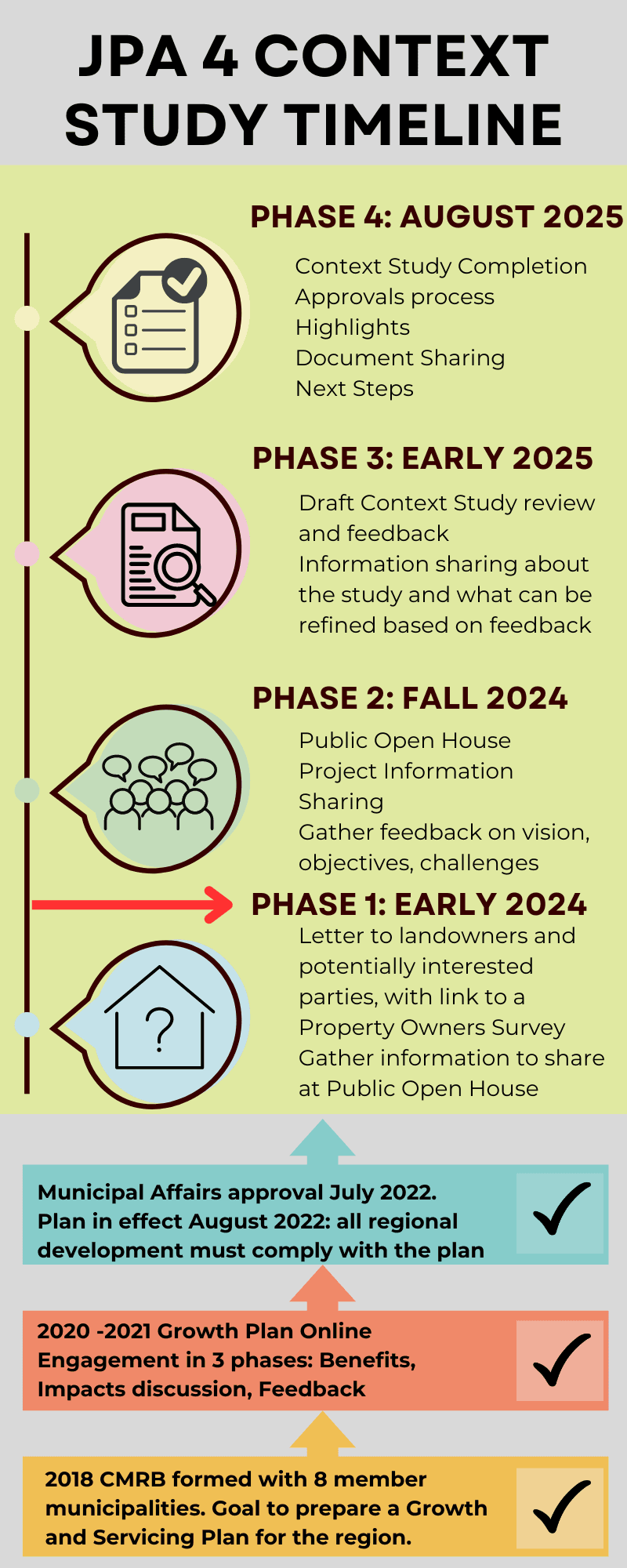
The Engagement Plan lays out four phases of engagement as follows:
Phase 1 (early 2024): We are here!Landowners within and adjacent to the study area along with identified potentially interested parties will be contacted by direct mail or email. The mailing list includes:
The letters will inform landowners and interested parties about the project and invite them to provide input regarding their priorities for future development, issues of importance in the area, and perceived opportunities and challenges. The method for providing input will include a survey and may include in-person or virtual meetings with the project team if requested.
Phase 2 (fall 2024):
This phase of engagement will re-engage with area landowners and interested parties and will also include the general public.
Phase 3 (early 2025):It is anticipated that Phase 3 of engagement will be primarily on-line.
Phase 4 (mid 2025):In this phase, communications will focus on sharing information about the completion and approval of Context Study. The approved study, study highlights and other relevant documents will be shared with landowners, interested parties and the public including posting to the project web page. Click on the timeline graphic below on a separate page to view or print. |

CMRB Growth Plan Background Information
The CMRB's Growth Plan will set the stage for the next 25-30 years, and for an anticipated population increase of one million people.
During the development of the Growth Plan there were three phases of public engagement between 2019 and 2021. The Growth Plan and accompanying Servicing Plan were both approved in July 2022 and came into effect on August 15, 2022. All development in the region must now comply with the Growth Plan.
Developing the Growth Plan, 2019-2021
Between the fall of 2019 and Spring of 2021 the CMRB municipalities worked with a consultant to create the Growth Plan. This process included 3 phases of public engagement:
- Phase 1 - Understanding the common benefit and identifying common values: June and Sept 2020
- Phase 2 - Informing on what was being proposed and discussing impacts: November of 2020
- Phase 3 – Gathering feedback on the proposed plan: March 2021.
After approving the Growth Plan and the Servicing Plans the CMRB then submitted them to the Minister of Municipal Affairs for final approval. A Ministerial Order approving the plan was issued in July 2022, with the plan coming into effect on August 15, 2022. All development in the region approved after this date must comply with the Growth Plan.
About the Calgary Metropolitan Region Board (CMRB) - Information and Links
The Calgary Metropolitan Region Board (CMRB) was established by the Government of Alberta in 2018 and includes eight member municipalities.
Under provincial legislation, municipal members of the CMRB were required to work together to prepare a Growth Plan and a Servicing Plan to ensure a strategy is in place to prepare for growth in the region. This work was completed between the fall of 2019 and the spring of 2021.
The CMRB's Regional Vision:
“Building on thousands of years of history, we welcome everyone to join us in living happy, healthy and prosperous lives in a spectacular natural environment. We are a world leading Region built on hard work, resilience, helping others and a deep respect for nature. We use our land wisely, share our services and care for our wildlife, air and water. We grow together.”
The CMRB's mandate is:
- Ensuring environmentally responsible land-use planning, growth management and efficient use of land;
- Developing policies regarding the coordination of regional infrastructure investment and service delivery;
- Promoting the economic wellbeing and competitiveness of the CMR; and
- Developing policies outlining how the Board shall engage the public in consultation.
CMRB's Approach to Managing Growth
CMRB's Approach to Managing Growth
- Preferred Placetypes are identified in the Growth Plan as a way to manage growth and promote certain types of development. These are located in specified areas that are deemed “Preferred Growth Areas.”
- Preferred Growth Areas include all lands within urban municipalities, hamlet growth areas within rural municipalities and four Joint Planning Areas (JPAs) that each include lands in two or more municipalities.
- Joint Planning Area 4 (JPA 4) is made up of lands in Foothills County and the Town of High River. It encompasses an area where it was deemed a coordinated approach to land use and servicing could be beneficial.
Below are the Preferred Placetypes in the Growth Plan, with descriptions provided for each:
Masterplan Communities:
- A Greenfield Development characterized by its comprehensive and integrated approach to land use.
- It will typically include a mix of housing types and land uses, including retail, commercial, civic, and recreational
amenities located within walking distance of residences. - This Placetype includes community or neighbourhood commercial centres.
- It requires safe and direct pedestrian and bike access between uses.
- Medium density employment is encouraged along with community or neighbourhood commercial centres in this pedestrian friendly area.
- These communities should be designed to evolve over time to higher densities and a greater mixture of uses. They can be inclusive of Mixed-use Transit-Oriented Development Placetype.
Mixed Use / Transit Oriented Development:
- A Greenfield Development or infill development characterized by mixed use development with many day-to-day services within walking distance of residential.
- These areas have a variety of housing types, employment types, and commercial / retail land uses mixed within them.
- When supported by existing or planned transit, this Placetype is called Transit Oriented Development. It will provide frequent safe and direct pedestrian and bike access between uses.
- Higher density office development is encouraged along with regional, community or neighbourhood commercial centres in this pedestrian friendly area. This Placetype may be located within an Infill and Redevelopment Placetype.
Infill and Redevelopment:
- Development takes place on parcels of land that are vacant and within existing built-up areas, or that are occupied by structures or uses that are planned for replacement by more intense development.
- Development which takes place on parcels of land that are vacant and within existing built-up areas, or that are occupied by structures or uses that are planned for replacement by more intense development.
- Such development may vary in Density and use according to the character of the surrounding community.
- They may be commercial, mixed, or primarily residential as the context requires.
Transit-Oriented Development:
- Development located within 400 metres of an existing or planned transit corridor that includes dedicated transit lanes or right-of-way, planned and developed as a mixed use, pedestrian-friendly community.
- Where possible, major employment and regional or district level retail can be integrated with housing.
In growth area locations, this can lead to collaboration and multiple benefits for residents on reducing such things as:
- Water consumption
- Travel and vehicle mileage
- Cost of infrastructure
- Land use
- Carbon emissions
Contact Us
Contact Us:
You are invited to contact Foothills County or the Town of High River Planning & Development staff with your questions. We are committed to engaging with landowners, residents, businesses and other key interested parties when making decisions that have the potential to impact them.
Foothills County contact information:
- Email Julie Mclean, Deputy Director of Planning
- Telephone: 403-603-6239
- View the Foothills County JPA 4 web page.
Town of High River contact information:
- Email Sarah Peck, Planner II
- Telephone: 403-652-2110
We're here to help, contact us!
Town of High River Contact

309B Macleod Trail S.W., High River, Alberta

Monday to Friday 8:30am - 4:30pm (Closed on statutory holidays)

planning@highriver.ca

403-652-2110
Foothills County Contact

309 Macleod Trail, High River, Alberta T1V 1M7, Box 5605

Julie.Mclean@FoothillsCountyAB.ca

403-603-6239
Foothills County Website
